Poland is not a destination most people I know would come up with, if I asked them for tips where to spend the Easter long weekend. However, visiting Park Narodowy Gór Stołowych turned out to be just perfect for such occasion.
I already noticed this area just across the Czech north-eastern border from Náchod a few years ago, but only now actually made the trip with my girlfriend. The national park is very small – the four days we had were just enough time to walk through pretty much all of it – but the paths and the nature in general is very varied and pleasant. Once you drive up to the hills from Kudowa Zdrój (where we were spending our nights), there’s relatively little elevation to gain or lose on any of the possible hikes, but the terrain is quite rough at some places and some fallen trees (victims of some kind of a gale storm) have been kept lying across the path in some place. This, however, just makes longer hiking more fun.
We were not only lucky to enjoy perfect weather – sunny, clear skies, not too hot – but had the pleasure to wander through the area just before the start of the tourist season. This meant that the woods and even the main tourist spots weren’t crowded with people, as I expect they would be later in the year.
Our hikes:
(Note that the distances at Mapy.cz – see links below – tend to be underestimated, but then on the other hand my watch struggled to hold onto decent GPS signal and probably overestimated the distance, so the truth will be somewhere in between.)
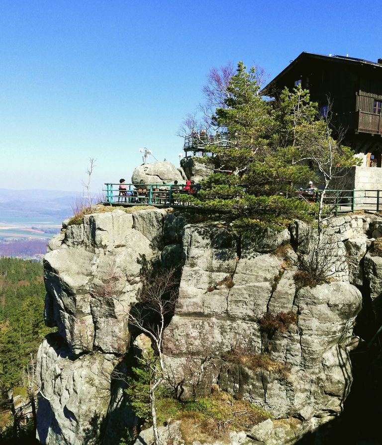
Day 1 (Friday, April 19): After a slightly frustrating drive (roadworks, crazy traffic) from Prague directly to Karłów, we walked up to Szczeliniec Wielky – the main attraction of the area, a rocky table-mountain with wonderful views thanks also to being the highest point of the park. We then explored the rocks and outlook points at the top before walking down and walking a circular route around the whole mountain (so that we could at least call it a warm-up hike – a roughly 11 km walk in 2 h 45 min).

Day 2 (Saturday, April 20): We drove up the terrible road from Kudowa Zdrój and parked near Lisia Przełęcz, from where we then walked the red route to the impressively formed rocky labyrinth of Błędne Skały. After squeezing through the labyrinth and admiring this natural work of sculpture, we took the educational trail back to where it met the red route and returned to the car.

Following a short break and a snack, we set off on the second part of our hike – this time on the other side of the road. We now hiked a beautiful circuit over Narożnik (blue signs) all the way to Skały Puchacza and then back along the yellow route through Biale skały. The whole trip including breaks and a short visit to Fort Karoła at the end took us 6 h 30 min (around 25 km).

Day 3 (Sunday, April 21): Our longest trip started at a parking spot where the red tourist route crosses the main road a short drive down the hill after passing Karłów. Walking east on the red route soon took us to the area of Skalne Grzyby – rocks shaped like mushrooms of various sizes scattered in the forest. We then followed yellow signs to Rogacz, then on to Batorów – a seeming ghost town somewhat lost in time – and to Skała Józefa, where we finally took a break sitting down, eating and looking south across the valley to the peaks of Orlické hory. We then continued along the green route, eventually switched to yellow and walked back to the area of the mushroom rocks. We then passed a bit lower and headed west, following green and later blue signs along an undulating horizontal path that ultimately took us to „Baszty“ (also called Radkowskie Bastiony on the local signs) – an outlook point among sandstone towers on the ledge of Radkowskie Skały. Then it was just a short, but a bit annoying, hike up the main road back to the car. (Again around 6 h 30 min, but closer to 30 km this time.)

Day 4 (Monday, April 22): On our last day, the morning was windy and the air very crisp and cool. We drove to the „YMCA parking“ area (just before the toll road to Błędne Skały) and walked toward the labyrinth before taking a turn left (red route) and hiking down hill to Jakubowice. After crossing the road in the upper part of Kudowa Zdrój, we intended to take the green and blue routes back up the hill, but soon learned that fallen trees blocked the path and that it was now closed. This made us change our plans, return the same way along the red route and at least make a circle to Błędne Skały and then back to the car park taking the educational trail that we had already walked a part of on Saturday. Anyway, this was still a very nice trip of around 15 km (3 h 30 min).
We used the Galielos.pl hiking map (1:30,000 scale), which also shows hiking times between main points.